Module 01 · Payload Scanner

Every truck, measured. No stops. No spreadsheets.

An overhead LiDAR gantry at the mine gate. Trucks drive through at haul-road speed. Volume, tonnage and truck ID land in your system before the truck reaches the weighbridge queue — which you probably don't need anymore.

Request a pilot → See specifications
The problem

Four ways your payload data is wrong today.

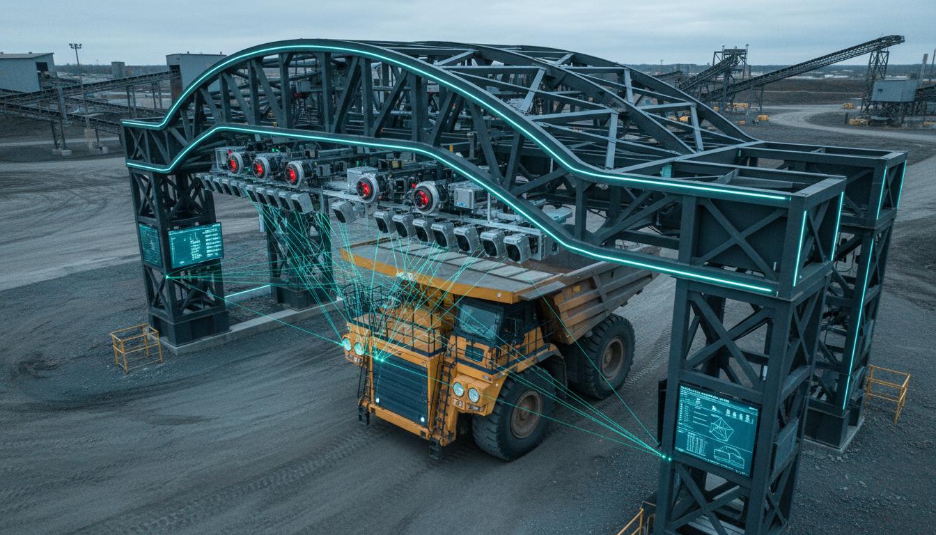
The weighbridge is a single number arriving at a single point. It tells you what the truck weighed at the bridge — not what left the loader, not what stayed stuck in the bed, not whether the load was centred. The difference shows up in trucking factor, in tyre wear, and in quarterly reconciliation meetings nobody enjoys.

Loader filling haul truck
Underload / Overload

Volume guesses, not measurements.

Operators fill by eye. Revenue leaks both ways — under on capacity, over on tyre wear and fuel.

Haul truck dumping ore
Carryback

Sticky residue inflates empty-bed baselines.

Every cycle drifts. Tonnage accuracy erodes quietly until someone runs the numbers at quarter close.

Off-centre loaded truck
Off-centre loading

Suspensions wear. Spillage builds up.

Bias in load distribution costs maintenance budgets and hauls material onto haul roads. Invisible to a bridge.

Truck at weighbridge
Drift between scan and bridge

Reconciliation isn't a control point.

Losses between loading and weighbridge are attributed to "shrinkage" because nothing else can describe them.

How it works

Scan. Analyse. Act.

A continuous measurement pipeline built into the haul road — not another system your team has to log into.

Scanner gantry over haul road
01 · Capture

Truck passes under the gantry.

LiDAR builds a volumetric point cloud of the loaded bed. Stereo cameras capture imagery. ANPR reads the number plate; RFID takes over in dusty conditions.

Analytics dashboard
02 · Analyse

Volume to tonnage. Automatically.

Point cloud becomes volume. Material density converts to tonnage. Empty-bed profile compared against loaded to isolate carryback. Results are in your ERP within seconds.

Alert on site tablet
03 · Act

Shift-level trends. Exception alerts.

Dashboards per route, loader, operator and shift. Alerts when loads drift outside tolerance. Timestamped photo audit trail for every trip — exportable.

Specifications

Industrial hardware. Edge-native software.

Built on mechanical LiDAR — chosen over solid-state for its wider field of view and more robust refresh rate at mine-haul speeds.

LiDAR range
Up to 200 m
Point density
1 million points / second
Laser configuration
16 / 32 / 128-laser (configured per site)
Volumetric accuracy
±2 cm at 10 m — >95% tonnage accuracy with calibration
Drive-through speed
10–15 km/h (no stopping)
Vehicle identification
ANPR primary · RFID fallback
Mounting
Overhead gantry, 6–8 m height
Enclosure
IP65 · dust and water resistant
Operating temperature
−10 °C to 50 °C
Dust mitigation
Integrated water-wiper system for sensor glass
Power
240 V AC · ~600 W typical
Network
Ethernet 1 Gbps · optional 4G fallback
Data export
REST API · webhooks · MQTT · CSV / JSON
How it compares

Versus weighbridges and imported scanners.

Capability Weighbridge Imported scanner MineVision
Measurement type Static weight Volumetric LiDAR LiDAR + stereo imaging
Throughput impact Stops required Drive-through Drive-through, 10–15 km/h
Carryback detection No Partial Yes — empty vs loaded profile
Indian procurement fit Low Forex · long lead times Make in India · tender-ready
Support timezone Local vendor Eight time zones away Hyderabad + Jharkhand
ROI calculator

What are the losses costing you?

A first-pass estimate of annual recovery with continuous payload measurement. Pilot data sharpens these numbers significantly.

Your site parameters

Estimated impact

Annual revenue loss (current)
Recoverable annually
Payback period
3-year net ROI

Assumes 60% of current losses are addressable via continuous measurement, 300 operating days, and a pilot-to-scale system cost of ~₹1.2 Cr. Actual figures vary by site.

For procurement

Tender-eligible. Documentation-ready.

Indigenous product, in-country support, and the compliance trail your procurement and compliance teams need — packaged at engagement, not requested afterwards.

Origin & compliance

Indigenous hardware, firmware, AI models and integration layer. Full origin documentation available on engagement.

Tender pack

Technical specifications, compliance statements, reference deployment summaries and commercial terms in the formats Indian mining tenders expect.

Warranty & SLA

Standard on-site warranty, SLA-backed uptime commitments, and scheduled maintenance contracts available as part of the deployment package.

Reference visits

Operational pilot site in Jharkhand available for site visits, including sensor demonstrations and parallel-weighbridge accuracy review.

Deployment

Pilot in months. Scale in quarters.

A phased rollout that protects uptime and proves value before scale.

Month 1

Site survey & mounting design

Site visit covering dust levels, truck mix, entry/exit geometry, power and network. You receive a formal technical report of the kind state mining authorities routinely request.

Month 2–3

Installation & calibration

Gantry fabrication and installation (2–3 days on site). Power, network, calibration. Parallel operation with existing weighbridge for accuracy verification.

Month 3–5

Pilot operation & reporting

One quarter of live operations. Daily shift reports, weekly accuracy reconciliation, monthly ROI tracking against baseline. All data owned by you.

Month 6+

Integration & scale

Full integration with your mine ERP. Operator training, go-live support. Additional modules (conveyor, mapping) added based on pilot outcomes.

Common questions

Frequently asked.

Does it slow down truck throughput?
No. Scanning happens in under 3 seconds as the truck passes under the gantry at 10–15 km/h. Drive-through operation is reliable at mine-haul speeds with modern LiDAR refresh rates.
What installation is required?
An overhead gantry at 6–8 m height at the ROM exit or haul road. Typical install is 2–3 days including power, network and calibration. We handle fabrication, siting and integration.
How accurate is it in real mining conditions?
LiDAR accuracy is ±2 cm at 10 m distance. Volume-to-tonnage accuracy exceeds 95% for typical mining materials with proper calibration. Pilots include parallel weighbridge verification so you can measure accuracy against your existing baseline.
Can it detect carryback?
Yes. The system captures empty-bed profiles and compares them against loaded scans, so residue in the truck bed is detected and accounted for in tonnage calculations.
How does it handle dust and monsoon conditions?
The enclosure is IP65 rated and operates between −10 °C and 50 °C. Sensor glass is kept clear by an integrated water-wiper system. Heavy rain can temporarily reduce accuracy; normal mining dust has minimal impact on LiDAR performance.
How does it integrate with existing mine management systems?
Data is available via REST API, webhooks or MQTT. We provide connectors for common mine ERP systems and can develop custom integrations as part of deployment.
What if the number plate is obstructed by dust?
ANPR is primary, RFID is the fallback. Both systems run in parallel so truck identification stays reliable even when visibility drops.
Is this product Make in India compliant?
Yes. Hardware, firmware, AI models and integration layer are all Indian-developed. Full origin documentation is provided at engagement for procurement and compliance review.

Run it for a quarter. Read the numbers.

See the difference in your trucking factors, with data you can audit.

Request a pilot →